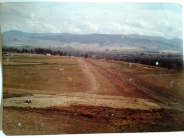
Stevensville Airport Sept 1980
|
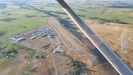
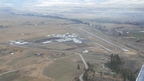
Stevensville Airport March 2017
|
Stevensville Airport Background and History In 1901 a land grant to V. Burch began the foundation for the Stevensville Airport at its present location [Appendix, History Timeline]. The airport is located approximately 5 miles from the Town limits sitting on a bench that provides a clear view of the Bitterroot Mountains to the west and the Sapphire Mountains to the east. Anyone, anywhere at the Airport has one of the most beautiful, unobstructed views in the Bitterroot Valley. This geographic location is considered by certain pilots to be one of the best locations for an airport in western Montana.
From 1901-2013 the airport has been developed by volunteers. The Airport history is shown in the Timeline and History appendices. The airport was being considered for closure and elimination due to disrepair by the FAA in the late seventies. A group of pilots and users approached the town to volunteer their efforts and funds to keep the airport at the established location. In 1979 an arrangement was reached whereby the volunteers would accept responsibility for the development of the airport with the understanding that there would be no costs to the town or general taxpayers. The airport would, however, be owned by the town of Stevensville. This arrangement continued throughout the main development of the airport up to the annexation which occurred in October of 2013. The airport is managed by the town council with recommendations by a six member volunteer airport board. Maintenance and on site operations are staffed by volunteers for snow plowing, mowing, and general upkeep.
During the major development period 1980-2013, virtually all the investment was seeded by volunteer user and business fees, individual contributions of labor, materials, and cash donations. These selfimposed fees (unique to this airport) allowed the volunteer management to secure both private and federal funding for capital improvements, such as realigning of the runway, paving , maintenance, developing a fueling station, purchase of snow plow equipment, etc.
At the time of annexation the layout of the airport was fixed as 32S which can be found in the current 2017 Montana Airport Directory, the 56th edition. By 2013 the volunteers had developed 27 buildings and a lighted 3800 x 60 runway with a lighted beacon and a self-service fueling station. The Airport Layout Plan [Appendix, ALP] was established, including timelines for many future improvements.
In 2013 at annexation, the town of Stevensville began receiving airport taxes, paid by the airport hanger owners. The county collects taxes for all taxing jurisdictions. These taxes went in to the Town’s general fund. Prior to the annexation no portion of the taxes paid by the airport hanger owners went to the Town. The airport budget now includes a portion of the operational costs of the town such as fire, police, clerks, mayor, etc. as an annexed property zoned light industrial. With the annexation in 2013, the airport entered a new relationship with the community. A Targeted Economic Development District (TEDD) was implemented in 2013. The Town, by resolution, created a Joint North Stevensville and Stevensville Airport Tax Increment Finance District Advisory Board to make recommendations to the Town on these two Districts. More interaction with the Town is occurring. [Appendix, Stevensville Targeted Economic Development Plan]
The airport users and volunteers have funded one of the town’s greatest assets. Current Airport Specific Total Economic Impacts for Stevensville Airport (32S) shows 68 jobs, a payroll of $1,933,000 and an economic impact of $7,780,000. [Appendix, MDOT 2016 Stevensville Airport Economic Impact Report]
|
History Timeline of the
Stevensville Airport 32S
Condensed version*
1901
US Patent for land granted to
Vincent Burch
1908
Beginning of land acquisition for the land to become Airport
1925
Ravalli
County acquires land to become Airport
1932
County executed 3 yr. lease for 50 A. to Stevensville to be used as an
airport
1933
County executed 5 yr. lease for
100A. to Stevensville to be used as an airport
1945
All land containing the Airport was declared to be owned by the
county due to forfeiture of the land by the then present
owners.
1947
Creation of
joint airport board for airports in Hamilton and Stevensville
1967
Amendment
to Resolution creating a joint airport board to be able to fix fees and rentals
06/071979
A restraining order was issued on approving County funds for Stevensville
Airport Improvement Project. Judge Green ordered an election so voters could
decide if County monies could be spent.
08/29/79
Results of the election for expenditure of county money for
the proposed Stevensville Airport Capital Project were against the expenditure
1979
Commissioners signed resolution 234
resolving that County Commissioners give notice to the city of Hamilton and the
town of Stevensville that the commissioners terminate the Joint Resolution
entered by all parties on November 3, 1947
1979
Stevensville
presented proposal to Commissioners requesting clear title to the Stevensville
Airport
1980
Stevensville summitted letter to commissioners
requesting Airport be turned over to the town of Stevensville.
1980
County commissioners repealed, terminated, and
abolished Joint Airport Board for Hamilton and Stevensville
1980
County
Commissioners assigns to the Town of Stevensville all rights that they may have
acquired to any recorded or unrecorded leases on the Stevensville Airport. Town
decrees that no taxes from the town or county are to be used to
support the airport. Users agreed to
fund airport without such financial support. Airport fees and newly applied
business and user fees were saved for utilization toward matching Federal funds
for airport improvements. All management and maintenance continues as volunteer
efforts. All property taxes go to the county. Incidental assistance given by
the town. Airport value unknown-four hangers exist now. Without tax revenues, a
diverse group of passionate aviation enthusiasts begin to fund and develop the
airport property into a more acceptable facility
Stevensville Airport RW 12 September
1980 Delbert Schwaderer photo
2013
Annexation
Airport annexed into Town of Stevensville. Taxes from airport properties now go to the Town of Stevensville as
well as the county and other taxing jurisdictions. TEDD district
established. Airport fees, business fees, and user fees continue to be the
supporting funds for the airport. New TEDD revenues go into a special fund for
the airport. FInancial history shows that Airport investment has been Federal funds
$3,458,885.33, matching volunteer user and business fees $229,407.23 for a
total of #3,688,292.56. Only two original hangers remain, but a total of 27
hangers and a SRE building have been developed for an estimated value exceeding
$4,500,000.00. A diverse group of passionate aviation enthusiast have funded
and developed the Stevensville Airport into a very nice facility. The lighted
runway is 60x3800 with taxiways, parking areas, self-service fueling station,
rotating beacon, large snowplow, and a PAPA exist with minimum debt now.
Volunteer efforts continue to maintain and operate the airport.
Stevensville Airport 26 June 2016 Craig E. Thomas photo
2016 Construction
begins on Airport improvements consisting of runway width to 75 feet, complete
resurfacing, and a full-length taxiway. Airport value now exceeds
$10,000,000.00. Maintenance and operation continues to be by volunteer efforts
Stevensville Airport 32S March 14, 2017 Chris Soto photo
*Further details are available from the doc “Stevensville Airport” authored
by then Airport Board Chairman Ron McCann and then Mayor Gene
Mim-Mack 02/13/2012.
|
|
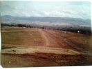 |
| Delbert Swaderer Photo Sept 1980 |
|
|
 |
| It's a short Flight from Stevensville to USFS airstrip Fish Lake. |
|
|
 |
| N13XZ in front of Structural Repair |
|
|
 |
| Stevensville Airport under construction 2016 |
|
|
 |
| 14 March 2017 Chris Soto photo |
|
|
Town of Stevensville received this award for excellence for the airport improvements 2016.
|
|